Uncategorized

Vet Care Industry Consolidation in Connecticut

Mapping the ownership and consolidation of Connecticut’s veterinary hospitals has both symbolic and practical significance. From the preliminary map our group has produced for this project, we found that nearly half of all locations whose ownership we verified were consolidated by a larger corporation. Further, we can see that these consolidated veterinary hospitals are clustering near one another, from our data collection process we recognize that this is often the result of a single consolidator establishing a local town or county-wide monopoly on animal care. Taking the most conservative estimate, assuming all hospitals with currently unknown ownership are local and that all hospitals identified as local are correctly identified, approximately 25% of all veterinary hospitals in Connecticut are consolidated. National estimates are nearly identical, also at 25%. If this consistency holds for other estimates made by the same consulting firms, it’s possible that these 25% of vet hospitals that are consolidated account for over 50% of all veterinary care, revenue, and client visits in Connecticut as they do at the national level (VIN). This is the map’s symbolic meaning, though conveyed through statistics they outline a snapshot of the consolidation of veterinary care in Connecticut.

Vet Care Industry Consolidation in Connecticut Read More »

Mapping Greenspace at Wesleyan University

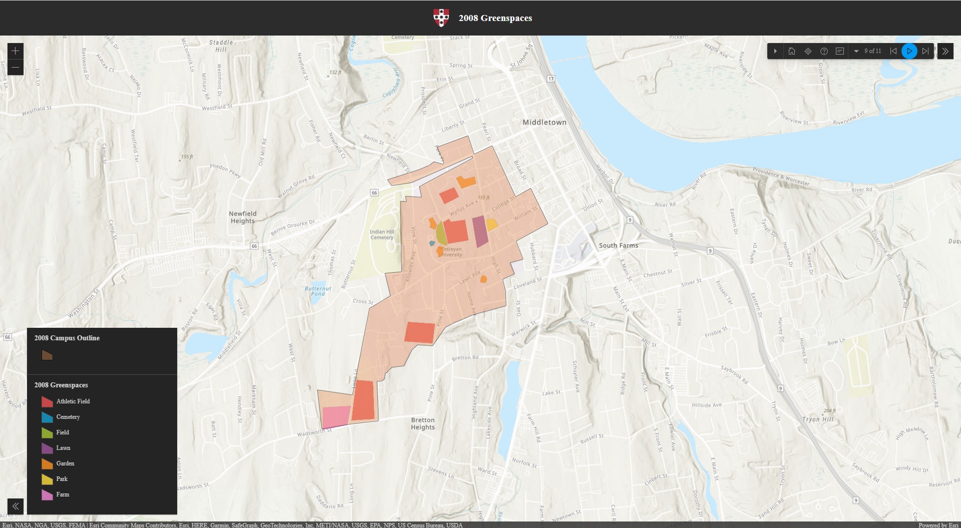
Our project, Mapping Greenspace at Wesleyan University seeks to chronicle how campus grounds have expanded over time and how greenspace has changed with that. We see greenspace as a part of campus structure that was intentionally placed for use by students rather than a passively accepted expanse. Everything about the area that Wesleyan owns is intentional, being that they have bought many buildings and land in the surrounding Middletown area and consistently have made plans for the space as a whole to fulfill the mission of the university. We define greenspace as any park, field, farm, lawn, garden, cemetery, athletic field, or forest (where they still exist) that is usable by both Wesleyan students and members of the community.

Mapping Greenspace at Wesleyan University Read More »

Image of Mapping Connecticut's Citizen Environmental Activism project

Mapping Connecticut’s Citizen Environmental Activism

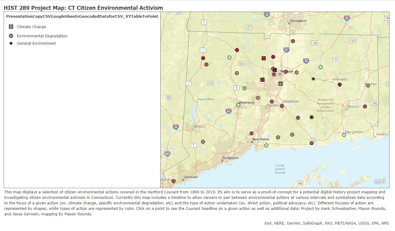
For our final project, we created a map of the history of climate action in Connecticut. By mapping Connecticut’s activism, we sought to place isolated events into the larger picture of the environmental movement. Connecticut residents may feel like their local environmental struggles are unique to their area, when in fact they are part of a larger pattern of activism in the state as a whole. By showing the scale and frequency of individual protests, our map seeks to encourage support for wide-reaching, holistic climate action and legislation, while also staying attentive to the local contexts of environmental actions. Digital mapping projects provide unique opportunities to engage with hyperlocal practices while simultaneously remaining aware of patterns of action, as described in critical digital projects like HyperCities. The map also aims to place Connecticut’s activism within the larger pattern of the national environmental movement, its history, and its future direction. Our map serves as an educational resource about the environmental movement, illustrating the conceptual and practical shifts in the movement’s focus from conservation to environmentalism to climate activism. By visualizing the dynamics of previous movements, it also serves as an aid for inspecting the successes and failures of past actions, helping contemporary activists strategize for the future.

Mapping Connecticut’s Citizen Environmental Activism Read More »

Interstate Highways and Segregation in Hartford

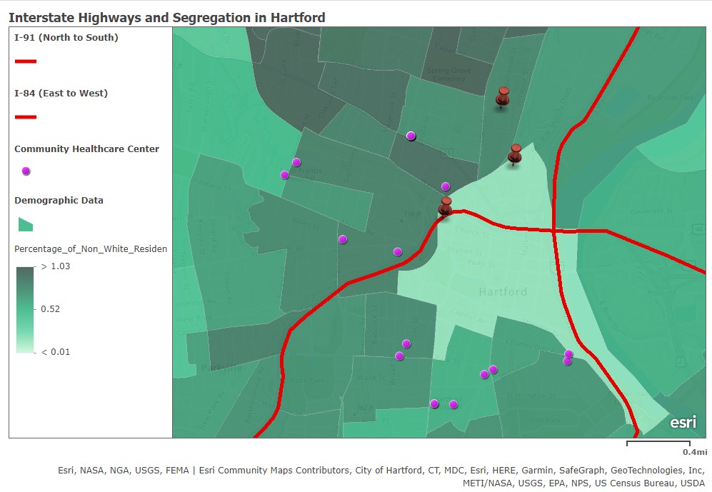
The current map version of the map acts as an excellent baseline, providing a historical narrative while providing a wealth of opportunities for continued work. Immediately building upon our visualization of how the highway affects the demographics of the city would be a deeper historical dive into how these divisions formed, from segregated public housing projects to disaster vulnerability, with an increased level of analysis of historical demographic data that would allow researchers to visualize neighborhood changes throughout the 20th century, rather than just the aftermath of these policies and events. An analysis of the economic inequality created by these policies would serve to emphasize the urgency of this issue. In addition to working with community partners, incorporating a community perspective into the map would serve to balance a historical record that has excluded the voices of the residents of Hartford. Rather than simply mapping a lack of access to care, a community-based approach could allow for greater visibility of health issues that could be caused by the highway, as the unseen effects of the highways unrelated to city planning and transportation is important in understandings the consequences of the inequalities of the past in the present day. Overall, the map visualizes some of the important aspects of inequality in Hartford, but one that can be added to and improved upon in service of a community partnership.

Interstate Highways and Segregation in Hartford Read More »