Introductions/1960s

SUMMARY: The period of the 1960s has come to be defined by powerful social uprisings against the systemic racial discrimination perpetuated by de facto segregation in educational, legal and social systems. Entirely intertwined with these spheres of violence is the use of excessive force as a weapon of control by law enforcement agencies, as a means to physically uphold these systems of racial discrimination. As December 1969 closes out the decade, members of the Black and Latinx community in Hartford, Connecticut file a class action lawsuit against the Hartford Police Department for subjecting them to unconstitutional and senseless violence. This class action lawsuit would come to be known as Cintron v. Vaughan.

Continue ReadingIntroductions/1960s

Cintron v. Vaughan​

This project tracks the fifty-year lifespan of Cintron v. Vaughan, a consent decree which placed the Hartford Police Department (HPD) under judicial oversight from 1973 to 2023. The case began as a class action lawsuit brought in 1969 against members of the HPD and city government by community organizations as well as Black and Latinx citizens who had experienced police abuse. Cintron may be the first and longest-running consent decree entered into by a U.S. police department, and yet it is relatively unknown in discourses surrounding police reform.

Continue ReadingCintron v. Vaughan​

Mapping Greenspace at Wesleyan University

Our project, Mapping Greenspace at Wesleyan University seeks to chronicle how campus grounds have expanded over time and how greenspace has changed with that. We see greenspace as a part of campus structure that was intentionally placed for use by students rather than a passively accepted expanse. Everything about the area that Wesleyan owns is intentional, being that they have bought many buildings and land in the surrounding Middletown area and consistently have made plans for the space as a whole to fulfill the mission of the university. We define greenspace as any park, field, farm, lawn, garden, cemetery, athletic field, or forest (where they still exist) that is usable by both Wesleyan students and members of the community.

Continue ReadingMapping Greenspace at Wesleyan University

Mapping Connecticut’s Citizen Environmental Activism

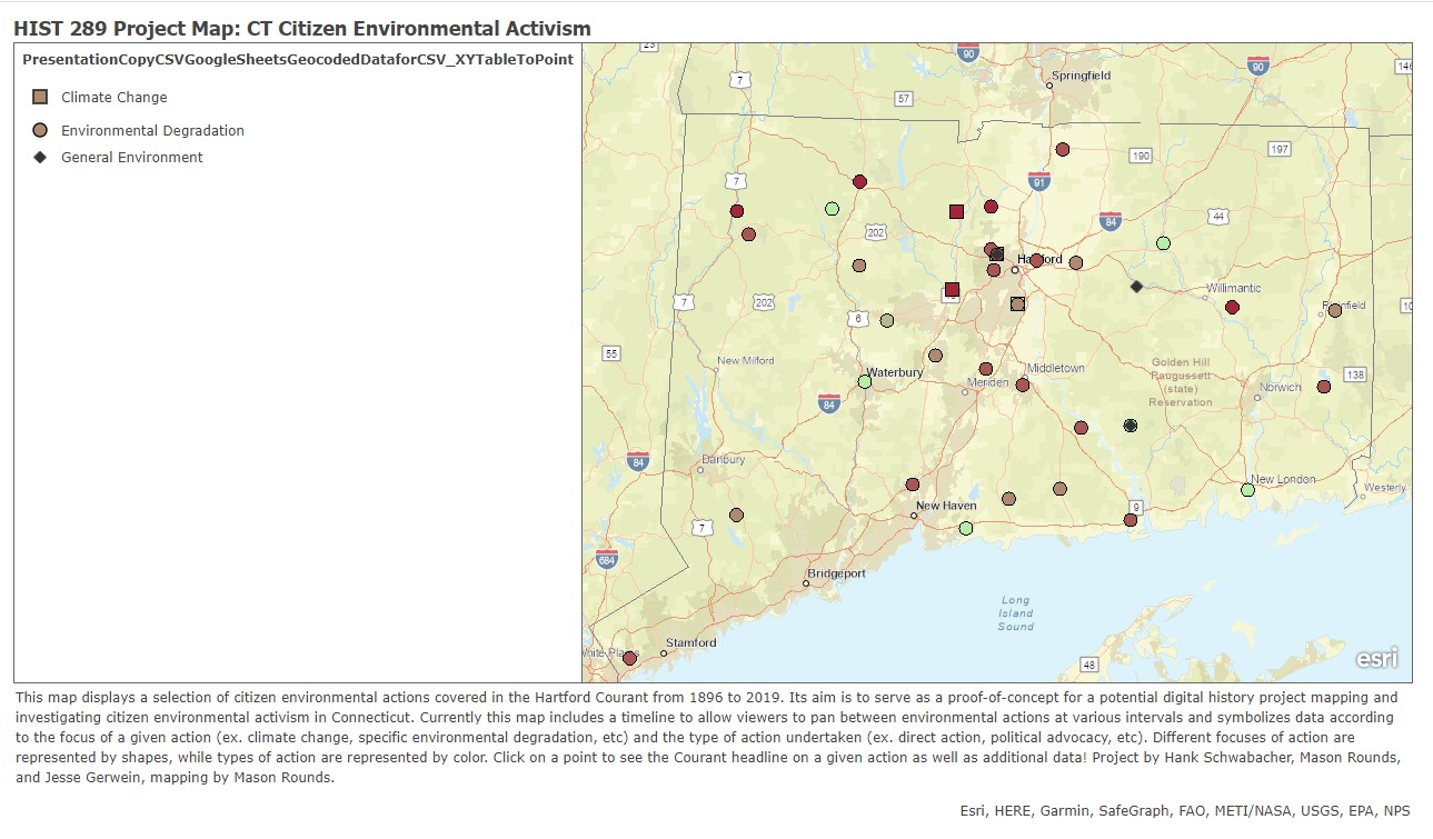
For our final project, we created a map of the history of climate action in Connecticut. By mapping Connecticut's activism, we sought to place isolated events into the larger picture of the environmental movement. Connecticut residents may feel like their local environmental struggles are unique to their area, when in fact they are part of a larger pattern of activism in the state as a whole. By showing the scale and frequency of individual protests, our map seeks to encourage support for wide-reaching, holistic climate action and legislation, while also staying attentive to the local contexts of environmental actions. Digital mapping projects provide unique opportunities to engage with hyperlocal practices while simultaneously remaining aware of patterns of action, as described in critical digital projects like HyperCities. The map also aims to place Connecticut's activism within the larger pattern of the national environmental movement, its history, and its future direction. Our map serves as an educational resource about the environmental movement, illustrating the conceptual and practical shifts in the movement’s focus from conservation to environmentalism to climate activism. By visualizing the dynamics of previous movements, it also serves as an aid for inspecting the successes and failures of past actions, helping contemporary activists strategize for the future.

Continue ReadingMapping Connecticut’s Citizen Environmental Activism

Interstate Highways and Segregation in Hartford

The current map version of the map acts as an excellent baseline, providing a historical narrative while providing a wealth of opportunities for continued work. Immediately building upon our visualization of how the highway affects the demographics of the city would be a deeper historical dive into how these divisions formed, from segregated public housing projects to disaster vulnerability, with an increased level of analysis of historical demographic data that would allow researchers to visualize neighborhood changes throughout the 20th century, rather than just the aftermath of these policies and events. An analysis of the economic inequality created by these policies would serve to emphasize the urgency of this issue. In addition to working with community partners, incorporating a community perspective into the map would serve to balance a historical record that has excluded the voices of the residents of Hartford. Rather than simply mapping a lack of access to care, a community-based approach could allow for greater visibility of health issues that could be caused by the highway, as the unseen effects of the highways unrelated to city planning and transportation is important in understandings the consequences of the inequalities of the past in the present day. Overall, the map visualizes some of the important aspects of inequality in Hartford, but one that can be added to and improved upon in service of a community partnership.

Continue ReadingInterstate Highways and Segregation in Hartford

Policing in the United States

This course examines the history of policing in the United States, beginning with its 19th-century origins, modeled after the practices in England, and continuing to the contemporary moment. We shall investigate the theory and practice of policing in a number of domains and from different perspectives. These include examining the origins of the surveillance state and the creation of the FBI, the militarization of police forces, the role and experiences of Black police officers, and the complex relation of policing to social movements and issues of racial justice. The class concludes with a discussion of the Federal Government’s response, in the form of commissions to the systemic issues surrounding policing. (Photo copyright: Philipp Baer)

Continue ReadingPolicing in the United States

Citizens, Judges, Juries: Who Decides in Democracy? 

The tensions between rule by the people, rule by elites, and rule of law are at the core of democratic theory. What is the proper balance among the three? Under what circumstances is one group of decision makers better than another? What happens when they come into conflict? We focus on the following topics: the role of voting in liberal democracies, the Athenian jury system, deliberative democracy, referendum and initiatives, civil disobedience, and the role of juries in the U.S. criminal justice system.

Continue ReadingCitizens, Judges, Juries: Who Decides in Democracy? 

Reenacting Justice: Guns in America

Combining oral history, visual storytelling methods, and documentary performance in a workshop format, this course will reenact court transcripts and contemporary and historic testimonies related to guns and gun violence in America. These reenactments are based on testimonies and documents collected that interpolate the legal issues around guns in the U.S. and the impact of guns on American society, especially on women, children, and communities of color.

Continue ReadingReenacting Justice: Guns in America

Guns and Society

This course examines the changing place of guns in U.S. society, from the colonial era through to the present day. Readings and discussions consider guns both as material objects involved in specific ways of life and as symbols and sites of contested meaning in American culture. Projects explore how guns have been, and remain, intimately involved with questions of race, gender, class, labor, capital, war, resistance, repression, vigilantism and ideas of freedom and self-defense. Special emphasis is placed on student research in local archives and museums in the Connecticut River Valley, the nation’s historical gun manufacturing center.

Continue ReadingGuns and Society

Visualizing the Past: Contesting Space with Digital Mapping

This course gave students the skills to challenge common narratives and reconceptualize spaces through the practice of digital mapping. Students surveyed the latest in spatial and digital scholarship while also learning how to produce community-engaged mapping projects. This course addressed foundational questions and themes in public humanities related to recovery, repair, co-creation, and community engagement. Course work included reviewing existing digital projects, identifying community partners for a collaborative mapping project, learning data and mapping methods, and exhibiting a mapping project.

Continue ReadingVisualizing the Past: Contesting Space with Digital Mapping